|
Introduction
The Safety Element of the General Plan is required by State law. It specifies policies applicable to new development and outlines programs that County government should implement to help improve public safety, particularly during times of natural or human-caused disasters.
Guiding Objective #2 calls for the General Plan to identify land that is “adequate and appropriate” for development. The policies in the Safety Element directly implement this Guiding Objective by directing development away from areas where hazardous conditions exist, and where development is therefore inappropriate.
Guiding Objective #2
Identify land that is adequate and appropriate for the residential, commercial, and industrial development needs of Monterey County during the next twenty years, taking into account land located within the cities, existing legal lots of record, and resource and infrastructure constraints.
Safety – Goal #1
MINIMIZE THE POTENTIAL FOR LOSS OF LIFE AND PROPERTY RESULTING FROM GEOLOGIC AND SEISMIC HAZARDS |
Safety – Policy #1
Direct Development To Non-Hazardous Areas – Minimize the potential for loss of life and property damage resulting from geologic and seismic hazards by directing new development to areas free of hazardous conditions.
Safety – Policy #2
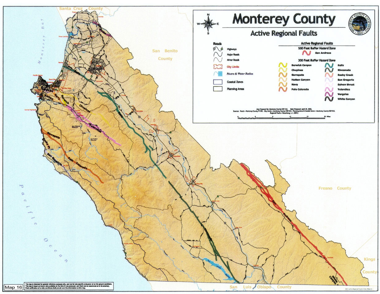
Geologic Hazard Zones – The County shall use the current Geologic Hazards Database in the County Geographic Information System (GIS), as illustrated on the following maps, to identify areas susceptible to geologic hazards. Areas identified on the following maps are hereby determined to be Geologic Hazard Zones:
Safety – Policy #3
New Development Generally Prohibited - New development shall be prohibited in Geologic Hazard Zones, unless a site specific study, based on original work by a qualified Registered Geotechnical Engineer, certifies that the area proposed for the new development is free of hazardous conditions.
Safety – Policy #4
Geotechnical Reports – Site-specific geologic hazard and geotechnical reports shall be required as part of the planning phase of development review and approval for any construction or new development proposed within a Geologic Hazard Zone, as follows:
| a. |
Geotechnical reports prepared by State of California licensed Registered Geotechnical Engineers are required during building plan review for all habitable structures and habitable additions over 500 square feet proposed within a Geologic Hazard Zone. Such a Geotechnical report may be required for additions less than 500 square feet, and for non-habitable buildings, based on a determination of site conditions, following a site inspection.
|
| b. |
Foundation conditions must be reviewed and approved in writing by a Registered Geotechnical Engineer prior to plan check approval, and if recommended by the geotechnical report, the registered Geotechnical Engineer shall perform a site inspection to verify that the foundation will meet the conditions established in the geotechnical report, prior to approval to pour the footings. Setbacks shall be identified and verified in the field prior to construction.
|
| c. |
New development and subdivision applications in State or County designated Earthquake Fault Zones shall be subject to review and approval of a geologic report addressing the potential for surface fault rupture and secondary fracturing adjacent to the fault zone before the application is considered complete. The report shall be prepared by a Certified Engineering Geologist and conform to the State of California’s most current Guidelines for evaluating the potential for site hazard or surface fault rupture.
|
| d. |
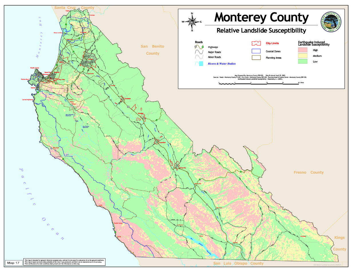
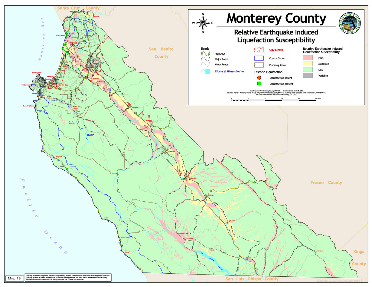
Geologic reports and supplemental geotechnical reports for foundation design shall be required for sites in areas with moderate or high landslide or liquefaction susceptibility as shown on Maps 17 and 18, or as determined by a site inspection. These reports must evaluate the potential for landslide or liquefaction onsite and offsite, including impacts on subdivision layouts, grading, and/or building structures.
|
| e. |
Where geologic reports with supplemental geotechnical reports determine that potential hazards affecting new development do not lead to an unacceptable risk to life or property, development may be permitted, if such development complies with all other applicable General Plan policies.
|
| f. |
Appropriate site specific mitigation measures, including deed restrictions, and mitigation monitoring to protect public health and safety shall be required as part of development approvals for any construction or new development within Geologic Hazard Zones. |
Safety – Policy #5
State Seismic Hazard Zones – The County will enforce applicable regulations of the Alquist-Priolo Earthquake Fault Zoning Act pertaining to avoidance of development on faults believed to have Holocene activity. As of [date this General Plan policy is adopted], the State Geologist has not completed designating Seismic Hazard Zones in Monterey County under the Seismic Hazards Mapping Act. When these zones are delineated, the County will enforce the applicable regulations.
Safety – Policy #6
Grading Requirements - Side castings from the grading of roads and building pads shall be removed from the site unless they can be distributed on the site without changing the natural landform. An exception to this policy will be made for those cases where changes in the natural landform are required as a condition of development approval.
Safety – Policy #7
Geologic Hazard Area Development Prohibitions – No new parcels shall be created in Geologic Hazard Zones. The construction of new structures on existing parcels that are at high risk from fault rupture, landslides, or coastal erosion shall not be permitted unless findings are made, based on substantial evidence in the record, that to prohibit construction would constitute a taking of the property, and that mitigation measures recommended by a Certified Engineering Geologist will reduce the hazards to an acceptable level. In such case, the recommended mitigation measures, and waivers of County liability, must be incorporated into the project and recorded on the property deed as a condition of approval. As a general rule, construction shall not be allowed in the following areas:
- Areas within 50 feet of Holocene or active faults. Within State or County Earthquake Fault Zones, trenching or other suitable methodology shall be used to determine the location of the fault.
- Areas within or adjacent to large active landslides. Large active landslides are those which are economically or technically infeasible to mitigate because of their rate of movement, size and volume, or proximity to other improvements or properties.
- Areas containing slopes over 25 percent.
- Areas within 50 feet of the face of a cliff or bluff or within the area of a 20 degree angle from the toe of a cliff, whichever is greater. This setback may be greater if it is determined that the rate of erosion will place the structure in jeopardy within a 100-year structural life expectancy.
Safety – Policy #8
No Construction In Hazard Areas - Construction shall not be permitted in areas of known geologic or seismic hazards unless findings are made, based on substantial evidence in the record, that 1) there is no alternative which would allow development on the parcel; 2) that waivers of County liability have been obtained; and 3) that mitigation measures recommended by a Certified Engineering Geologist are found to reduce the hazards to an acceptable level. In such case, the recommended mitigation measures and waivers of County liability must be incorporated into the project and recorded on the property deed as a condition of approval. Known areas of geologic hazard include:
- Areas of moderate or high relative landslide susceptibility.
- Areas of moderate to high relative erosion susceptibility.
- Areas of moderate or high relative liquefaction susceptibility.
Safety – Policy #9
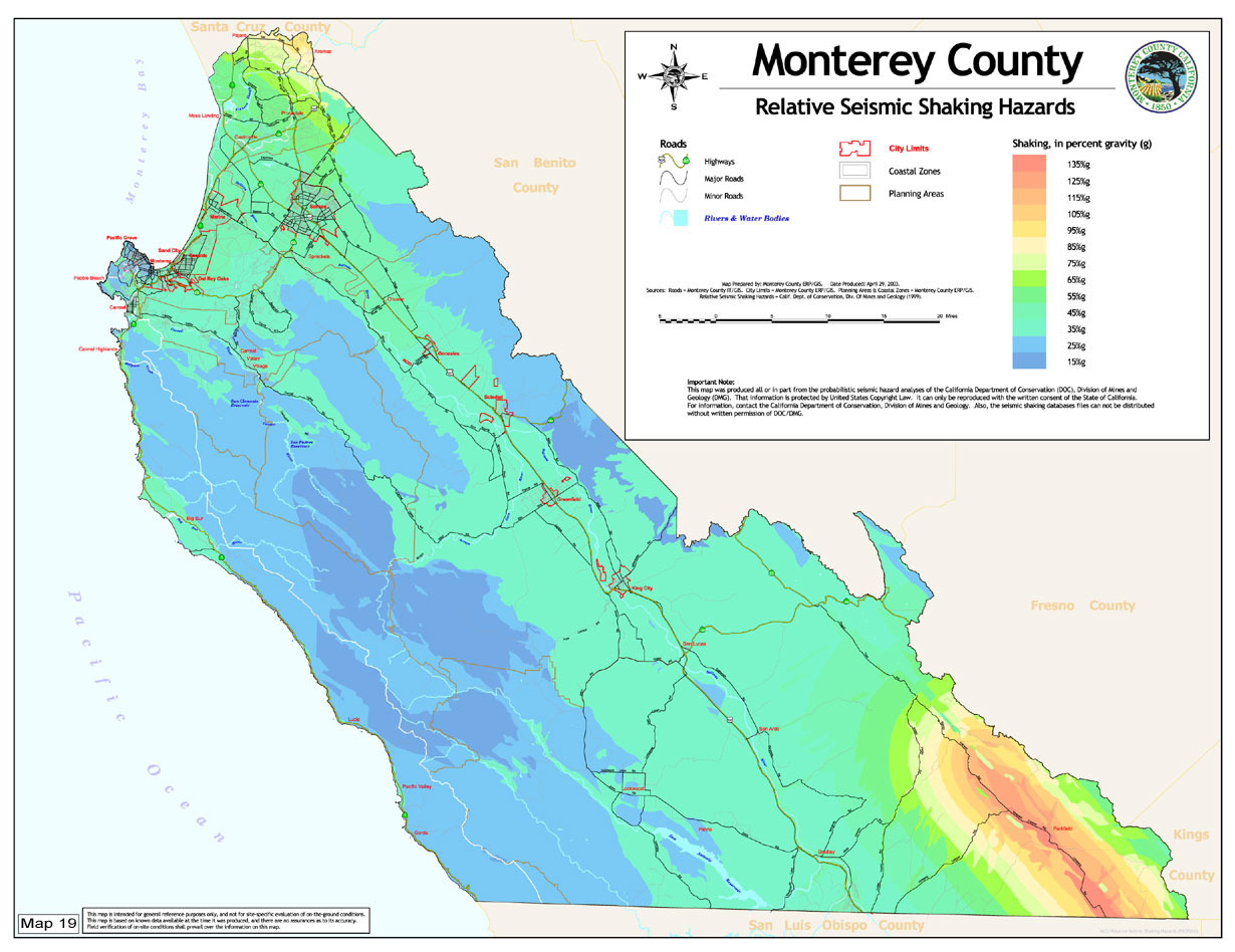
Professional Assessment of Geologic Hazards – The County shall require a licensed Certified Engineering Geologist to prepare a geologic report meeting state standards that evaluates new development for potential fault rupture, ground shaking, liquefaction, landslides, and seismic settlement in accordance with the currently adopted Uniform or International Building Code and the standards promulgated by the State Geologist. The County will enforce applicable building code regulations pertaining to the siting and design of structures and grading relative to seismic hazards.
Safety – Policy #10
Professional Peer Review of Geologic Reports – Reports, technical documents, and plans for conformance with applicable codes and regulations pertaining to identification and mitigation of potential geologic and seismic hazards shall be reviewed by a State of California licensed Certified Engineering Geologist, either on County Staff or as an independent third party consultant selected by and employed by the County. Reports shall remain on file at the Planning and Building Inspection Department.
Safety – Policy #11
Naturally Occurring Asbestos – The County shall protect public health from naturally occurring asbestos by requiring mitigation measures to control dust and emissions during construction, grading, quarrying or surface mining operations. Construction, grading, quarrying or surface mining operation development proposals within identified areas of serpentinite rock formations shall require a geologic evaluation and must prepare an Asbestos Dust Mitigation Plan if serpentinite or ultramafic rock is identified.
Safety – Policy #12
Demonstration of Compliance – An environmental document including a geologic report with supplemental geotechnical report must demonstrate that all the criteria in this General Plan have been met and recommendations for mitigation measures are consistent with these policies. Site investigation guidelines and recommended mitigation measures shall follow the guidelines of the California Geological Survey and the County of Monterey, where applicable.
Safety – Policy #13
The County shall continually update seismic and other geologic information to reflect the most current and accurate information available, and such updated information shall replace outdated reports referenced in this Element.
Safety – Policy #14
The County shall continue to review and may adopt new editions of the Uniform Building Code or International Building Code as appropriate.
Safety – Policy #15
The County shall amend the Uniform Building Code as necessary.
Safety – Goal #2
REDUCE THE RISK FOR DAMAGE TO LIFE AND PROPERTY CAUSED BY FLOODING, DAM INUNDATION AND TSUNAMIS
|
Safety – Policy #16
Improve Community Rating System Classification – Monterey County shall strive to improve its National Flood Insurance Program Community Rating System classification by implementing additional activities and enforcing stronger floodplain development policies.
Safety – Policy #17
Flood Maps – The approximate floodway and 100-year floodplain boundaries are delineated on the Flood Hazards Map (Map 20) or, if more recently updated, the FEMA Flood data. For individual properties, official flood zone designations shall be obtained using FEMA Flood Insurance Rate Maps and Floodway Maps. The County shall maintain updated FEMA Flood Insurance Rate Maps and Floodway Maps, and shall update the Flood Hazards Map every five years.
Safety – Policy #18
Prohibition of Incompatible Structural Development - The County’s primary means of minimizing risk from flood hazards shall be through land use planning and the prohibition of incompatible structural development in flood prone areas.
Safety – Policy #19
Open Space Uses Encouraged in Floodplain Areas -Open space uses such as agriculture, passive to low intensity recreation, and conservation are considered the most acceptable land uses in the floodplain.
Safety – Policy #20
Flood Area Development Prohibitions – No new parcels shall be created where the only developable sites for new structures are within the 100-year floodplain. On existing legal lots of record which are partly or completely located within the 100-year floodplain, all structures and attendant utilities shall be located outside the 100-year floodplain to the greatest degree possible. On legal lots of record with no alternative building site outside the 100-year floodplain, all new construction shall be limited in scope, elevated consistent with FEMA regulations, and conditioned upon review by the Monterey County Water Resources Agency. Approval of such development shall require waiver of County liability recorded on the property deed.
Safety – Policy #21
Notice to Future Property Owners – For new development on existing legal lots of record located within or partially within the 100-year floodplain, where no alternative building site outside the 100-year floodplain is available, a condition shall be placed on development approvals requiring the recordation of notices stating that the property is located within or partially within the 100-year floodplain, and that building and/or land use restrictions may apply to the property.
Safety – Policy #22
Rebuilding in the 100-Year Floodplain – Reconstruction of an existing structure located within the FEMA defined 100-year Floodplain shall be permitted only when the reconstructed structure is located above the base flood elevation. Any permitted reconstruction shall comply with a ten-year cumulative substantial improvement rule, or any other requirement adopted by the Water Resources Agency as part of a Repetitive Loss flood mitigation program.
Safety – Policy #23
Dam Failure and Tsunami Response – The County shall coordinate with appropriate public agencies in its planned response to failures and tsunami warnings. The County shall maintain dam failure and tsunami hazard maps, as available from the State Office of Emergency Services, and shall maintain an evacuation plan with guidance for public officials on emergency notification and evacuation instructions, including use of an emergency alert system to notify the public.
Safety – Goal #3
MINIMIZE THE RISK OF LOSS OF LIFE, INJURY, AND DAMAGE TO PROPERTY AND NATURAL RESOURCES RESULTING FROM FIRE HAZARDS
|
Safety – Policy #24
Fire Prevention Programs – The County shall coordinate with local fire agencies and the local Fire Safe Council to develop fire prevention programs. Public education programs should address appropriate and environmentally sound fire prevention measures for the environmental and geologic conditions of the area, including erosion control and environmentally sensitive habitat protection.
Safety – Policy #25
Fire Mapping – The High and Very High Hazard severity zones shall be as delineated on the Fire Hazard Severity Zones map in this General Plan, or as amended through subsequent mapping updates (Map 21). The County shall coordinate with state and local fire protection agencies to update the maps to reflect current conditions, with particular emphasis on the urban/wildland fire interface. The Fire Hazard Severity Zones map shall be updated every five years. Local fire jurisdictions may adopt additional fire hazard severity classifications for local responsibility areas (LRA) and shall coordinate with the County to provide updated fire hazards information.
Safety – Policy #26
Minimize Loss of Life and Property -It is the policy of Monterey County to minimize the potential for loss of life and property resulting from wildland fire hazards by prohibiting or restricting new development in High and Very High Hazard Severity Zones, as delineated on Map 21, by directing new development to areas of less hazardous conditions, and by providing programs for the purchase of development rights where, to avoid fire hazard, development cannot feasibly be relocated on an existing legal lot of record.
Safety – Policy #27
Prohibit or Restrict Development in Fire Hazard Areas – No new parcels shall be created in High and Very High Fire Hazard Severity Zones, as delineated on Map 21. New construction on existing parcels located in such High and Very High Fire Hazard Severity Zones shall not be permitted unless the following findings are made, based on substantial evidence in the record:
| a. |
That the structures proposed to be constructed cannot feasibly be relocated on the parcel to avoid fire hazard;
|
| b. |
That to prohibit construction would constitute a taking of the property;
|
| c. |
That no program is available for the purchase of development rights on the parcel on which the construction is proposed;
|
| d. |
That fire-safe design measures can be implemented to reduce the fire hazard risk;
|
| e. |
That notice will be given to current and future owners of the property, through a recorded deed restriction, of the available level of emergency and fire protection services and that County liability has been waived; and
|
| f. |
That the new construction will meet the fire protection service standards in this General Plan. |
Safety – Policy #28
A condition of approval for all new development shall be that the property is required to annex into the appropriate fire district. Where no fire district exists, project applicants shall provide verification from the most appropriate local fire authority that adequate fire protection services exist, and no new development shall be approved absent such verification. Project approvals for new development within High and Very High Hazard Severity Zones shall be conditioned to require a deed restriction notifying the property owner of the level of service available and acceptance of associated risks to life and property and that County liability has been waived. Where annexations are mandated to a fire district, as a condition of project approval, the County shall negotiate a tax share agreement with the affected fire protection district.
Safety – Policy #29
Project Review – The County shall refer development applications to the fire authority having jurisdiction to identify potential fire hazards and ensure that development in High and Very High Hazard Severity Zones is designed and constructed in a manner that minimizes the risk from fire hazards.
Safety – Policy #30
Fire Hazard Reduction Measures – Pursuant to recommendations made by the local fire authority, the County shall ensure that appropriate fire hazard reduction standards are incorporated into the design of the development, including the following:
| a. |
On parcels of one acre or larger, defensible space shall be achieved by a minimum 30-foot setback of the structure from the property line, with fire resistant landscaping or vegetation management recommended 30-100 feet from the structure, subject to exceptions if approved by the local fire authority having jurisdiction.
|
| b. |
Within a Significant Ecological Area (SEA), as described in the Conservation Element, the local fire authority shall be encouraged to allow standards to be modified to allow for fuel reduction measures that protect the habitat to the maximum extent feasible, while ensuring adequate fire protection and public safety. |
Safety – Policy #31
Notice to Future Property Owners – The County shall provide notice during the development application review process outlining the restrictions on siting and building standards in High and Very High Fire Severity Zones and describing mitigation measures that reduce the risk of fire hazards to an acceptable level. Deed restrictions which describe the nature of the hazard(s), outline mitigation measures, provide notice that County liability has been waived and, where appropriate, specify long-term maintenance requirements shall be required as a condition of approval in these areas.
Safety – Policy #32
Access – The County shall ensure that any new development approved by the County on rural lands located outside of a Community Area will have adequate access for fire and emergency vehicles and equipment, as specified by the fire authority having jurisdiction.
Safety – Policy #33
Minimum Fire Protection Standards – The County shall ensure that minimum fire protection standards are in place for all unincorporated areas outside State Responsibility Areas designated by the State Board of Forestry and where the state assumes financial responsibility for protecting natural resources from damage by fire.
Safety – Policy #34
Public Facilities in High and Very High Fire Severity Zones – The County shall not permit the location of critical public facilities in High or Very High Fire Severity Zones, with the exception of fire stations, unless there is substantial evidence in the record to indicate that there is no feasible alternative to locating such a facility in such a High or Very High Fire Severity Zone. When location of facilities in such areas is unavoidable, special precautions shall be taken to ensure an acceptable level of risk and uninterrupted operation of these facilities.
Safety – Goal #4
REDUCE THE POTENTIAL FOR HARM TO INDIVIDUALS AND DAMAGE TO THE ENVIRONMENT FROM HAZARDOUS MATERIALS, AIRCRAFT HAZARDS, RADIATION HAZARDS, ELECTROMAGNETIC FIELDS, AND HAZARDOUS TREES
|
Safety – Policy #35
Discretionary Development Applications – Development applications for projects that will use or generate hazardous waste shall include detailed information within the application regarding quantities of hazardous materials and hazardous waste delivery and storage, and the proximity to sensitive receptors such as schools, hospitals, and residential neighborhoods.
Safety – Policy #36
Hazardous Material Facility Control – The design, construction, and operation of commercial and industrial facilities which use, store, or transport hazardous materials shall be in accordance with applicable hazardous materials and waste management laws and regulations. No such facility shall be approved unless the County finds, based on substantial evidence in the record, that all feasible measures to eliminate or reduce the generation of toxic wastes have been incorporated into the project. Those facilities that use and store hazardous materials above state and federal threshold quantities shall be inspected annually by the County’s Environmental Health Division to ensure necessary measures are taken to protect public health and safety.
Safety – Policy #37
Hazardous Materials Response and Cleanup – The County shall maintain and implement a Hazardous Materials Incident Response Plan to ensure adequate handling and reporting of hazardous materials incidents, and cooperate with the State Department of Toxic Substances Control and Regional Water Quality Control Board to promote the timely and efficient cleanup of these sites.
Safety – Policy #38
Site Contamination Study – A study shall be conducted for all development projects which involve a change in use where past site uses suggest environmental degradation or possible contamination. Where such contamination is present, the County shall require a plan that identifies potential risks and actions to mitigate those risks prior to, during and after construction and occupancy consistent with all applicable laws and regulations.
Safety – Policy #39
Landfill Buffers – New development shall not be permitted within 2500 feet of active landfills, or within 1000 feet of closed landfills, unless findings are made, based on substantial evidence in the record, that to prohibit such new development would constitute a taking of the property upon which the new development is proposed. When new development is permitted, conditions shall be imposed on the new development to eliminate, to the greatest degree feasible, all potential impacts relating to noise, air or water quality degradation, odors, toxic contamination, public safety dangers, or other negative impacts related to the landfill, and that County liability has been waived.
Safety – Policy #40
Airport Safety Zones – In cooperation with the cities, the County shall update airport safety zones, as needed, and ensure land use designations comply with adopted airport land use plans.
Safety – Policy #41
Electromagnetic Fields – The County shall apply any electromagnetic field standards established by the California Energy Commission or the California Public Utilities Commission to County land uses potentially affected by electromagnetic field hazards.
Safety – Goal #5
PROTECT PUBLIC HEALTH, SAFETY AND WELFARE AS WELL AS PROPERTY BY TAKING PROACTIVE STEPS TO PREVENT, PREPARE FOR, RESPOND TO, AND RECOVER FROM THE EFFECTS OF MANMADE AND NATURAL DISASTERS
|
Safety – Policy #42
Emergency Plans – The County shall implement plans that provide for a coordinated and effective response to emergency and disaster events. The Monterey County Operational Area Emergency Operations Plan shall include general procedures to implement the statewide Standardized Emergency Management System (SEMS), activate and operate the Operational Area Emergency Operations Center (EOC), coordinate responders, and implement other tactical response measures. The County will maintain Coordinated Emergency Response Plans (CERP) for specific threat areas that include specific interagency coordination and joint response simulation exercises to include all elements and disciplines of the Monterey County Operational Area Authority. The County shall also:
| a. |
Continue to improve preparedness programs and utilize best practices to increase public awareness, educate and organize the public to respond appropriately to disasters, in addition to public safety and emergency service providers.
|
| b. |
Provide emergency and disaster related information to the public as events occur.
|
| c. |
Coordinate with utility providers during disaster events.
|
| d. |
Maintain an ongoing program to train building and safety personnel in risk assessment and ensure that County building codes keep current with State requirements.
|
| e. |
Maintain agreements with local, State and federal agencies to provide coordinated emergency response.
|
| f. |
Coordinate scheduled reviews of the Monterey County Operational Area Emergency Plans with all applicable agencies, including a review process for alternate routes of escape that will safely accommodate evacuations and emergency equipment to reflect the level of development. |
Safety – Policy #43
Geographic Information System (GIS) – The County will maintain hazard mapping capabilities within the County’s GIS and develop programs for sharing of information with other jurisdictions. Keep current databases on the location of hazards countywide and provide appropriate access to databases for emergency public service providers to improve delivery of public safety services.
Safety – Policy #44
Emergency Service Levels – The County shall:
| a. |
Evaluate emergency service capabilities and direct population growth into Community Areas to be better served during emergency and disaster events.
|
| b. |
Direct that improvements to emergency services be focused in areas with the highest concentration of development. |
Safety – Policy #45
Emergency Access – Emergency roadway connections shall be developed where distance to through streets creates an unsafe situation and where a second means of emergency access or egress is critical.
Safety – Policy #46
Critical Facilities – Critical facilities including fire stations, emergency operations centers, hospitals and other similar facilities shall be located, designed and operated in a manner that maximizes their ability to function after a disaster event. To support development and operations of these facilities, new development shall provide its fair share of necessary funding.
Safety – Policy #47
Roads, Facilities and Utilities – The County shall undertake all of the following with respect to the location of roads, facilities, and utilities:
| a. |
Encourage utility companies to institute orderly programs of installing cut-off devices on utility lines to prevent additional damage or hazards during natural disasters.
|
| b. |
Ensure that new roads, bridges, and utility lines shall be designed and constructed in accordance with all applicable safety standards.
|
| c. |
Ensure that utilities serving new development shall be sited and designed to minimize the risks from hazards to the greatest extent feasible. Where feasible, utilities shall be placed underground. |
Safety – Policy #48
Evacuation Routes – All public thoroughfares in Monterey County shall be considered potential evacuation routes. The Monterey County Coordinated Emergency Response Plans shall provide basic information on the evacuation routes for specific areas.
Safety – Policy #49
Tsunami Evacuation Routes – Tsunami Evacuation Routes area considered to be any route leading inland from the coastline to elevations twenty feet or higher.
Safety – Policy #50
Existing Development – The County should develop an inventory of at-risk structures and buildings, including unreinforced masonry buildings, and should prioritize hazard mitigation projects based on those providing the most benefit to the population of Monterey County. The County should work with property owners to identify and implement mitigation measures to abate the potentially dangerous buildings through retrofitting or demolition.
|