Area Plans – North County |
|
A PDF version of this page is available here: 24NorthCounty |
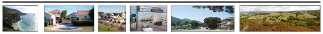
The North County Planning Area is a distinctive region containing scenic valleys and ridges, globally important agricultural lands, and Elkhorn Slough, which is part of the Monterey Bay National Marine Sanctuary and the Elkhorn Slough National Estuarine Research Reserve. Few areas of comparable size contain the variety of locations and quality of life offered in North County. Castroville and Pajaro have agriculture-based economies, while Moss Landing is primarily dependent on coastal industries. These communities offer urban densities with a "small town" or “village” character. The rural areas of Prunedale, Aromas, and Las Lomas provide a community focus for residents in nearby secluded valleys and canyons. The varying identities and lifestyles of North County will continue to be defined through the character of its small towns, villages and rural communities. North County residents would like to maintain their historically rural values, close-knit neighborhoods and unpretentious community. Residents are also proud of the area’s role and reputation in providing globally important agricultural products and are fiercely protective of its viable farmlands. Due to the close proximity of North County to metropolitan areas and their attractive qualities, North County has experienced tremendous growth and development in recent years. This has been particularly true in the Prunedale Area where proximity to Highway 101 makes it feasible for workers from other counties to locate here. Throughout the North County area, growth has left its mark on the land, and in the minds of long time residents, growth has diminished some of the qualities that attracted them to the area originally. Growth in the rural areas has brought traffic, noise, congestion, greater demands on limited urban services and increasing losses to the area’s potable water and other precious natural resources, including the majestic oak landscape and wildlife corridors. The North County Planning Area has unique soils and climates that allow for unusual crops and year-round cultivation. Growth has caused concern for the viability of agriculture and maintaining rural character. Vast areas of farmland at the northern and southern perimeters of the Planning Area, as well as rangelands to the east, maintain lifestyles that have prospered over many decades and residents remain closely tied to the land. A major issue is loss of this prime agricultural land to erosion and conversion to non-agricultural uses such as residential and commercial development. The availability and quality of water remains the most crucial issue facing North County. Water is critical for both agricultural and development demands. A key component of the Planning Area’s water issues is the Elkhorn Slough, with a 43,600 acre watershed. Lack of developed infrastructure, significant groundwater overdraft, nitrate contamination and saltwater intrusion into the groundwater aquifer are serious problems faced by all of the communities of North County. Some individual water/sewer systems and failing municipal systems are increasingly unable to meet the current and rising demand for development and services. The imposition of a water moratorium for new subdivisions (now no longer in effect) temporarily slowed development in the Planning Area. Some residents insist that long-term solutions to the critical water issues facing the Planning Area be addressed before additional growth is permitted. Aquifer recharge is a vital need. In order to achieve aquifer recharge, significant percolation areas must be protected, water sources higher in the aquifer must be used for irrigation, dual water systems should be created in new subdivisions, and landscape watering should use properly designed and inspected “grey” water or de-ionized nitrate laden water when possible. Additional creative solutions to the water crisis, such as the use of cisterns, must be investigated. Other important issues in the North County are traffic congestion on an inadequate country road network, such as the Highway 1, G-12 and Highway 156 corridors, and on State Highway 101. Residents are concerned about a lack of funding for infrastructure and understaffing of public safety and emergency response. In addition to the problems posed by existing development, it is important to recognize that additional impacts will result from build-out of the large number of existing vacant lots. The 1982 General Plan and subsequent Area Plan and Local Coastal Plan for this area placed over 28,000 acres (40 percent) of the total 69,000 acres into residential zoning categories. In 2002, there were 2,707 vacant residentially zoned parcels in this area. If more than one unit is built on each parcel, build-out may result in three or four thousand new units. In addition, there are approximately 480 vacant agricultural parcels on which residential development could be built. In order to make the land use plans and maps for the Planning Area consistent with the area’s vision, it will be necessary to limit future growth in some areas and direct reasonable growth to others. Until existing deficiencies in infrastructure and public safety systems are addressed, development must be limited to areas with sufficient services and infrastructure. North County can be a unique place where rural residential development and small towns coexist with globally important environmental resources and agriculture. That is the vision that North County residents desire. However, some tough choices have to be made. Simply maintaining the status quo will not reverse the current trends that undermine every aspect of this unique area. The preservation of Elkhorn Slough and its watershed is key to preserving North County. A positive vision for the future must include the preservation and restoration of an interconnected network of natural communities, including the sensitive coastal marshes within Elkhorn and Moro Cojo Sloughs, the freshwater wetlands of McCluskey Slough, a restored riparian habitat in the lower Carneros Creek, and unfragmented maritime chaparral within the series of upland ridges in the Elkhorn Highlands. In addition, the forest resources of North County must be protected. Policies must be developed to protect oak savannah and oak woodland plant communities during development. Sudden oak death, also called oak mortality syndrome, is a serious disease afflicting oak trees in Monterey County. The California Oak Foundation has determined that due to the complexity of the oak ecosystem, planting additional oaks elsewhere does not mitigate development impacts to mature oak woodland habitats. The mosaic of natural communities also includes productive and habitat-compatible agricultural land and operations and existing residential communities. In addition to making tough choices concerning where future growth should not occur, it is equally as important to determine where it would be appropriate. The small town of Castroville has been identified as having the potential to continue to grow and become a viable healthy community where its residents can raise families and receive an urban level of services. Pajaro also has the potential and need to develop additional housing for its residents. In the future, Pajaro and Castroville could accommodate additional housing development. Currently, there is a definite “mismatch” between the needs of the existing labor force and the type of housing available. Reconsideration of existing regulations such as limitations on residential use in mixed-use developments, height limitations, parking requirements, excessive setbacks, minimum building site size, building site coverage and parcel width and depth could help to accommodate full infill development prior to outward expansion. Building multiple units on existing buildable lots with water availability in appropriate locations is envisioned. Further information about these two communities is provided below. Communities such as Oak Hills, Elkhorn, Royal Oaks, Aromas, Las Lomas and Prunedale are rural in nature. To provide infrastructure to most of this area would be extremely costly. The small community of Moss Landing has also reached maximum residential buildout and additional housing development is not envisioned. The policies contained in this General Plan, which restrict most new development to designated Community Areas, while permitting construction on legal lots of record, will help ensure that the desired future for North County is achieved. In order to preserve the distinctive character of North County, the vision for the future is to make certain that applicable land use policies bring future development into balance with available resources and infrastructure. This will mean that no further subdivision should occur outside of the Community Areas of Castroville and Pajaro. Additionally, conservation and land use policies must be adopted that balance increased demands on the area’s limited water resources, assure conservation measures to protect and connect wildlife corridors, whenever feasible, and meet the requirements for the Monterey County Trails Network, control erosion and prevent destruction of critical habitat and the majestic oak landscape. The infrastructure systems and public safety services available in North County must be improved to eliminate existing deficiencies as well as to provide for future needs. However, these improvements must not induce or accommodate levels of growth inconsistent with community assets or the carrying capacity of the Planning Area’s natural resources. Castroville 4.7 persons. Castroville’s commercial core, currently underused, has potential for mixed-use development that can also contribute to meeting affordable housing goals. New commercial development in the Castroville area should be strategically located to serve area residents and visitors alike. Castroville’s goal is to improve and enhance the image, economic vitality and well being of the community and encourage visitors to the area, with an emphasis on retaining a small town character that recognizes the value and contribution of agriculture, cultural diversity, tourism and history of the community. Residents feel it should be a priority to make improvements to traffic circulation related to trucks and through traffic, water and sewage facilities; improved code enforcement and public safety; and providing flood relief from the sloughs surrounding the community. Residential Uses in Castroville Design guidelines should be adopted and used to guide future residential development to ensure consistency with these principles. Commercial and Industrial Uses in Castroville The Castroville Industrial Park is an important component of the community’s economy. Expansion of the park could offer additional employment opportunities, and maintain the position as an attractive location for industry. Transportation, Public and Quasi-Public Facilities in Castroville The Castroville community welcomes a conveniently located passenger rail station. Multi-modal transit-oriented development in conjunction with a station could provide attractive housing for existing residents and reduce commuter through traffic that currently impacts the community. Pajaro Pajaro’s future vision is a healthy balanced community in context with agricultural uses and the culturally diverse character of the Pajaro Valley. The community of Pajaro envisions a future in which it is largely residential, with friendly, compact neighborhoods; with safe, walkable streets; with convenient access to neighborhood shopping; and with a heavy industrial base that provides jobs and supports the surrounding agricultural use. The residents and businesses of Pajaro want to accommodate new development when it can provide expanded, affordable housing for the existing residents; when there is adequate infrastructure, including schools and community facilities; when it is balanced with the agricultural uses that provide local jobs; and when new development provides the impetus for redevelopment of the existing developed properties. Residential Uses in Pajaro Economic Opportunities, and Commercial and Industrial Uses in Pajaro Residents will welcome new convenience shopping that complement existing businesses, such as groceries, hardware, pharmacy and related goods and services. Improved medical clinic access will also serve existing residents. Pajaro is also a center for automotive repair, including commercial, agricultural and individual vehicles. Maintaining the viability of and providing new opportunities for these small businesses is important to the community. New locations for growth of some of these businesses, and clustering others would offer the opportunity to recycle land through cleanup of existing soil contamination, and potentially improve compatibility of adjacent uses. Transportation, Public and Quasi-Public Facilities in Pajaro A major priority for the businesses and residents of Pajaro is to improve pedestriansafety on Porter Street/Salinas Road. Making this road a genuine “Main Street” willbe the cornerstone for the future community. A future passenger rail hub in Pajaro offers an opportunity to explore thedevelopment of a multi-modal transit-oriented community adjacent to the station.Separation between freight, industrial, passenger and residential uses will be the keyto a successful design.The Pajaro River flood improvements will provide a new level of safety for thecommunity. Design of the improvements in a manner that protects agriculture,businesses and homes can ensure that the river is integrated into the community.
North County Policy #1 – Major Coastal Access Areas
North County Policy #2 – Secondary Coastal Access Areas
Public access to the sensitive habitats around Elkhorn Slough should be planned carefully. Existing access opportunities should be encouraged and promoted, and future access should be restricted to only those areas were various levels of human activity will not be deleterious to wildlife. North County Policy #3 – Snowy Plover Habitat North County Policy #4 – Elkhorn Highlands North County Policy #5 – Central Maritime Chaparral North County Policy #6 – Oak Hills and Monte del Lago North County Policy #7 – Coastal Wetland Restoration North County Policy #8 – Aquifer Recharge North County Policy #9 – Coastal Wetland Habitats North County Policy #10 – Tidal Scour in Elkhorn Slough North County Policy #11 – Tidegates At Moro Cojo North County Policy #12 – Archaeological Resources
The archaeological survey should describe the sensitivity of the site and appropriate levels of development, and recommend mitigation measures consistent with the site's need for protection, which measures shall be incorporated into any permit allowing development on the property. North County Policy #13 – Water Use North County Policy #14 – Groundwater Overdraft North County Policy #15 – Eucalyptus Trees North County Policy #16 – Union Pacific Railroad North County Policy 17 – Public Viewsheds |