The
following trends are documented in this 1999
report:
Population
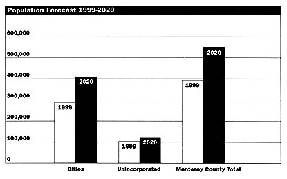
Monterey County's population is projected to rise
dramatically in the next 20 years, increasing by
37%, from a current population of 391,300 to a
projected population of 537,000 in the year 2020.
In 1997, Monterey County's population grew
approximately 4.7%. The County's 1998 growth rate
was 2.7%, making Monterey County the third fastest
growing county in California. Much of this
population growth is projected to occur in the
Salinas Valley.
Urban
Sprawl
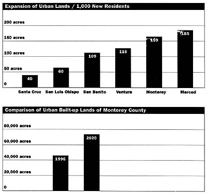
Existing planning practices encourage the
inefficient use of land. Currently, 159 acres of
land are converted to urban uses for every 1,000
new residents. If this rate remains constant
through the year 2020, an additional 23,800 acres
of land will be committed to urban development.
Monterey County's rate of urban land expansion is
significantly higher than in neighboring San
Benito, San Luis Obispo, and Santa Cruz
counties.
Approved
and Pending Projects
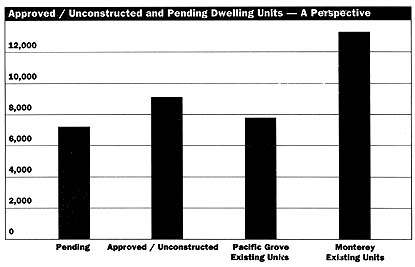
Monterey County and the cities either have approved
or are considering approval of 15,410 residential
units, 8.6 million square feet of commercial/
industrial projects, and 1,418 hotel/motel units.
Development of 1,226 lots of record on the Monterey
Peninsula (included in the 15,410 residential
units) depends on the availability of additional
water. The project list includes projects not
previously documented in the State of Monterey
County 1998 --an additional 3.6 million square feet
of commercial/industrial projects. The project list
excludes the projected buildout of the general
plans, the reuse of Fort Ord, and facilities for
6,800 students at California State University
Monterey Bay (CSUMB). The water and traffic impacts
resulting from the CSUMB facilities are included
because the facilities have been approved or are
pending.
Total
Approved/Unconstructed and Pending
Projects |
Project Status |
Dwelling Units
|
Commercial/
Industrial Sq. Ft.
|
Hotel Rooms
|
Approved/
Unconstructed |
8,167 |
4,975,099 |
701 |
Action Pending |
7,243 |
3,688,488 |
717 |
Total |
15,410 |
8,663,587 |
1,418 |
The approved/unconstructed and pending projects
throughout the county will add more dwelling units
than those which have already been built within the
City of Monterey and 28 times more commercial and
industrial square footage than the Edgewater
Shopping Center in Sand City.
Table
1 -- Approved and Unconstructed Projects by
Jurisdiction
Table
2--Pending Projects by
Jurisdiction
Loss
of Agricultural Lands
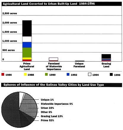
Existing planning practices encourage the
conversion of agricultural land to urban uses.
Between 1984 and 1998, 3,348 acres of agricultural
land, including over 2,300 acres classified as
prime, were converted to urban land uses. At risk
of conversion to urban land uses are 2,250 acres of
agricultural land, including 1,650 acres classified
as prime, which are within the spheres of influence
of the five Salinas Valley cities.
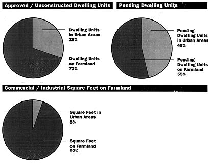
Approved but unconstructed projects
The approved/unconstructed projects have either
removed, or will soon remove, over 1,400 acres of
land from agricultural production. Of the 8,167
dwelling units in the approved/ unconstructed
category, 71% will be built on farmland. Of these
units, 99.5% will be on farmland within cities, and
.5% will be on farmland within the unincorporated
area.
Pending projects
The dwelling units in the pending category, if
approved, would convert 1,200 acres of productive
agricultural land to urban built-up uses. Of the
7,243 dwelling units under consideration but not
yet approved, 55% would be built on farmland. Of
these, 22% are in the cities, and 78% are in the
unincorporated area.
Almost 7.9 million square feet or 92% of the
commercial and industrial projects on the approved/
unconstructed and pending lists would be on
farmland.
Traffic
Congestion
Traffic congestion on local and state roadways is
getting worse. Highway congestion is measured on a
scale of Level of Service (LOS) A to F, with F
being the worst. Of the 15 state highway segments
evaluated, four are at LOS D, one is at LOS E, and
seven are at LOS F. Of the 18 local arterials
evaluated, nine are at LOS C, seven are at LOS D,
and one is at LOS F. Approved and pending dwelling
units, expected growth at CSUMB, and
visitor-serving projects would add 157,046 daily
trips to already congested highways, an increase of
15% over 1997 daily trips.
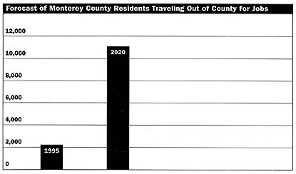
In 1995, measuring on a "net" basis
(in-commuters minus out-commuters), about 2,600
employed residents, representing 1.6% of the total
county workforce, commuted to jobs outside Monterey
County. By 2020, again on a "net" basis, about
11,000 residents, or 4.9% of the total workforce,
are expected to commute to work outside of the
county.
Transportation
Funding
Of the $388,645,000 estimated to be available for
capacity increasing road and highway projects in
the next 20 years, the Transportation Agency for
Monterey County has programmed 88% for the
Prunedale Bypass and Route 101 interchanges and
operational improvements near Prunedale. There is
no funding for improvements to Route 1 north of
Castroville, Route 1 near Seaside, Route 68 west
and east of Highway 1, Route 183 north of Salinas,
Route 218 from Highway 1 to Fremont, as well as
Fremont Boulevard, Blanco Road, and Reservation
Road. All these roads are at LOS D or below.
Consequently, it becomes increasingly important for
land use decisions to recognize transportation
funding constraints. 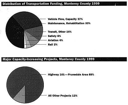
Water
Supply
The major population areas of the county have
serious water supply problems. Population growth on
the Monterey Peninsula surpassed the number of
people who can be served under California American
Water Company's (Cal-Am) production limits in the
early 1990s. The Salinas Valley Ground Water Basin
is overdrafted by 40,000 to 50,000 acre-feet per
year, or approximately 10% of the basin's safe
yield. In North Monterey County, annual water
extractions exceed average annual recharge by 100%.
Approved and pending developments would require
1,065 acre-feet of water per year from Cal-Am,
between 4,762 and 6,204 acre-feet per year from the
Salinas Valley Ground Water Basin, and 736
acre-feet per year from other sources. Aside from
850 acre-feet per year for CSUMB, most of the
projects requiring water from the Salinas Valley
Ground Water Basin would consume less water than
the agricultural uses they are replacing. However,
once water is committed to urban growth, a
long-term entitlement is created, and dry-year
demand is increased.
Water
Quality
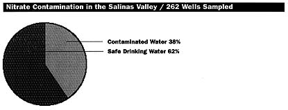
Groundwater use in the Salinas Valley is adversely
affected by nitrate contamination. A 1998 report
from the Monterey County Water Resources Agency
states that of 262 water wells sampled, 100 wells
(38%) had nitrate concentrations exceeding the safe
drinking water standard. Nitrate concentrations are
expected to rise in future years because of the 40-
to 60-year time lag between changes in nitrate
loading at the surface and corresponding changes in
groundwater.
Affordable
Housing
All available data indicate that the supply of
housing for lower-income persons is extremely
limited, and adequate affordable housing is not
being constructed as growth proceeds. No agency is
responsible for tracking affordable housing
countywide. No consistent method is in place to
quantify the construction of affordable housing by
the various jurisdictions over a specified period
of time. The Monterey County and the twelve cities
must collaborate to develop a consistent method to
track the construction of affordable housing and
the accomplishments of existing programs.
General
Plans
State law requires planning agencies to "prepare,
periodically review, and revise, as necessary, the
general plan." Numerous cities in the county are in
the process of updating their general plans. The
cities of King City, Marina, Salinas, and Sand City
are at various stages of the update process. The
cities of Carmel, Monterey, and Soledad will
consider initiating a general plan update during
the 1999/2000 Fiscal Year. The County of Monterey
has hired a consultant to develop a work program to
define the scope of a general plan update, and it
is anticipated that the County of Monterey will
initiate a general plan update during the 1999/2000
fiscal year. The Monterey County General Plan is 16
years old and most of its area plans are ten or
more years old.
General
Plans |
Jurisdiction |
Date Current Plan
Adopted |
Advisory Date For
Comprehensive Update |
Date Comprehenisve
Update Scheduled |
Monterey County |
1982 |
1987 |
1999 |
Carmel |
1989 |
1994 |
1999 |
Del Rey Oaks |
1997 |
2002 |
None Scheduled |
Gonzales |
1996 |
2001 |
None Scheduled |
Greenfield |
1981 |
1986 |
None Scheduled |
King City |
1999 |
2004 |
1998 |
Marina |
1982 |
1987 |
1998 |
Monterey |
1988 |
1993 |
2000 |
Pacific Grove |
1994 |
1999 |
None Scheduled |
Salinas |
1988 |
1993 |
1999 |
Sand City |
1989 |
1994 |
1999 |
Seaside |
1996 |
2001 |
None Scheduled |
Soledad |
1993 |
1998 |
1999 |
|