 |
Home | Issues & Actions | About |
Archive Page This page is available as an archive to previous versions of LandWatch websites. |
LandWatch
State of Monterey County Report 1999
3.5
Roads and Highways
Highway congestion is measured by transportation agencies on a Level of Service (LOS) basis, using a scale of A through F (A represents the best conditions; F represents the worst). The Monterey County Regional Transportation Plan has a goal to attain and maintain LOS C for the roadway network. Short-range goals are to allow no degradation below LOS D for urban roads now operating at LOS D or better, no degradation below LOS C for those rural roads now operating at LOS C or better, and no degradation below existing LOS for all other roads. Of the 15 state highway segments evaluated, four are at LOS D, one is at LOS E, and seven are at LOS F (Table 10). Route 183 from Davis Road to Route 1 has the highest accident rate. Of the 18 local arterials evaluated, nine are at LOS C, seven are at LOS D, and one is at LOS F (Table 11).(9) The LOS has decreased over the last three years at the following segment locations: Route 101 from Espinosa Road to San Benito County; Fremont Boulevard from North Del Monte Avenue to Route 1; Blanco Road from Davis Road to Blanco Circle; and Blanco Road from Reservation Road to Davis Road. Transportation
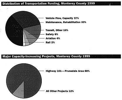
Funding Of the $388,645,000 estimated for capacity-increasing road and highway projects, 88% is planned for Prunedale Bypass and Route 101 interchanges as well as operational improvements near Prunedale (Table 13). Other highway improvements include about $7 million for operational improvements on Route 1 near Carmel and widening of Route 156 between Castroville and Prunedale. There is no funding approved for capacity-increasing projects on Route 1 north of Castroville, Route 1 near Seaside, Route 68 west and east of Highway 1, Route 183 north of Salinas, Route 218 from Highway 1 to Fremont, as well as Fremont Boulevard, Blanco Road, and Reservation Road. These roads are all at LOS D or worse. 
Vehicle Trips
|
|
CONTACT 306 Capitol Street #101 PO Box 1876 Phone (831) 759-2824 Fax (831) 759-2825 |
|

