Downtown Vitalization Specific Plan
At build out, the Marina Downtown Vitalization Specific Plan would allow 380,150 new square feet of multiple use, office/research, retail service and public facilities. It would also permit 2,400 new dwelling units with over 90% of them multi-family residential.
Quick Facts
- The project applicant is City of Marina.
- The project expands the space for multiple use, office/research and retail, and permits 2,400 new units.
- The City of Marina is the lead agency.
- This project is governed by City of Marina General Plan from 2000.
Project Status
- The Notice of Preparation of a Draft Environmental Impact Report was released in May 2021.
- There is a working draft of the Plan (31.8M PDF) available as of March 2011.
- The comment period was March 2010.
- The Notice of Preparation was complete in 2009.
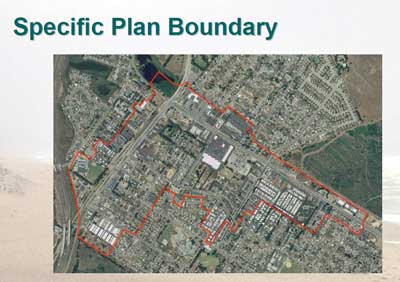
Project Location Map
This map shows the boundaries of the
Marina Downtown Specific Plan.

Full Size Map (582K PDF)
Credit: City of Marina, Public Workshop Presentation (August 2008)
Resources at Risk
- Language on Reclaimed Water is Unclear
In 2005, a plan was established to supplement the City’s water supply with a desalination plant. Upon completion, the desalination plan[t] is expected to supply 1,500 acre feet of water per year.” It is unclear if this document is referring to this exist plan or a different one. - Poor Evaluation of Water Supply Needs
The document does not adequately review impacts from developments in Marina Heights, Cypress Village, Marina Station or the Dunes.
LandWatch Involvement
LandWatch engages in the public process in a variety of ways. For this project, here is a list of our engagement strategies.
- Letter: Comments on the Specific Plan Environmental Impact Report (102K PDF)
LandWatch’s comments focus on water, the cumulative impacts analysis, and air quality. (04.07.11)
Monterey Peninsula
Issues & Actions
