General Plan Update
The City of Gonzales launched its 2010 revision of the City’s General Plan. The City is currently working with Monterey County on a Memorandum of Agreement that expands the City’s Sphere of Influence. In reviewing the City’s environmental document, LandWatch noted significant impacts to the environment, traffic, agricultural lands, and air and water quality. For this reason, LandWatch is now actively monitoring the situation and will work closely with our supporters to ensure our quality of life is maintained.
Quick Facts
- The agreement is proceeding through the City of Gonzales and the County of Monterey.
- The planning area is approximately 19,200 acres and contains the City of Gonzales (1,211 acres) and 2,150 acres of land for urbanization and 2,130 acres for urban reserve.
- The City of Gonzales is the Lead Agency
Project Status
- The General Plan was adopted January 2011. (6.2M PDF)
- Awaiting release of the Memorandum of Understanding (MOU).
- The Final Environmental Impact Report was released in December 2010. (25.6M PDF)
- The Draft Environmental Impact Report was released in July 2010. (17.7M PDF).
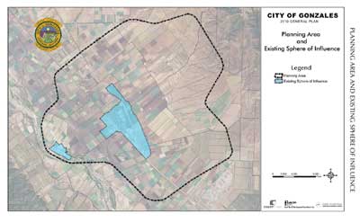
Project Location Map
This map shows planning area and sphere
of influence for the City of Gonzales.

Full Size Map (152K PDF)
Credit: City of Gonzales General Plan (January 2011)
Resources at Risk
- Poor Planning Practices
The document leaves out nearly 730 acres of unidentified land uses. In addition, the Draft Environmental Impact Report uses incorrect population estimates for the City–nearly 14,000 people more than Regional Forecasts. - Loss of Agricultural Resources
The conversion or loss of agricultural resources (160 acres) not only conflicts with the County’s existing zoning but are also significant and unavoidable impacts. - Traffic Impacts
Traffic impacts to Highway 101 and other streets are significant and do not meet the State’s General Plan guidelines for having roads accommodate land use designations. - Water Supply and Quality
Water supply issues also are prevalent with concerns about availability, existing water demand, and salt water intrusion.
LandWatch Involvement
LandWatch engages in the public process in a variety of ways. For this project, here is a list of our engagement strategies.
- Letter: Comments on the Memorandum of Agreement Negotiations (99K PDF)
LandWatch submits comments that may be helpful in the continuing negotiations between the County and the City of Gonzales. (07.19.12) - Letter: Comments on the Final Environmental Impact Report (106K PDF)
LandWatch provided substantive comments on the report’s population estimates, traffic models, traffic impacts, traffic calming measures, air quality, water, and more. (12.13.10) - Letter: Comments on the Draft Environmental Impact Report (213K PDF)
LandWatch reviewed the EIR and commented on the project description, population and housing, agricultural resources, transportation and traffic, air quality, and more. (09.20.10)
Salinas Valley
Issues & Actions